A short history of the Pale.
These notes are from a talk presented to our group: Why Did our Ancestors Leave a Nice Place Like the Pale? by Hal Bookbinder, hal.bookbinder@ucla.edu . This page is his copyright and may not be copied without his permission.
From the 1790s until World War I, Jews in the Russian Empire were for the most part restricted to Poland and the Pale of Jewish Settlement. The Pale consisted of the Vice regencies of Belorussia, Bessarabia, Lithuania, New Russia, and Ukraine. Poland was a separate entity which was merged into the Pale by the early 1870s. Each vice regency was composed of one or more guberniyas.
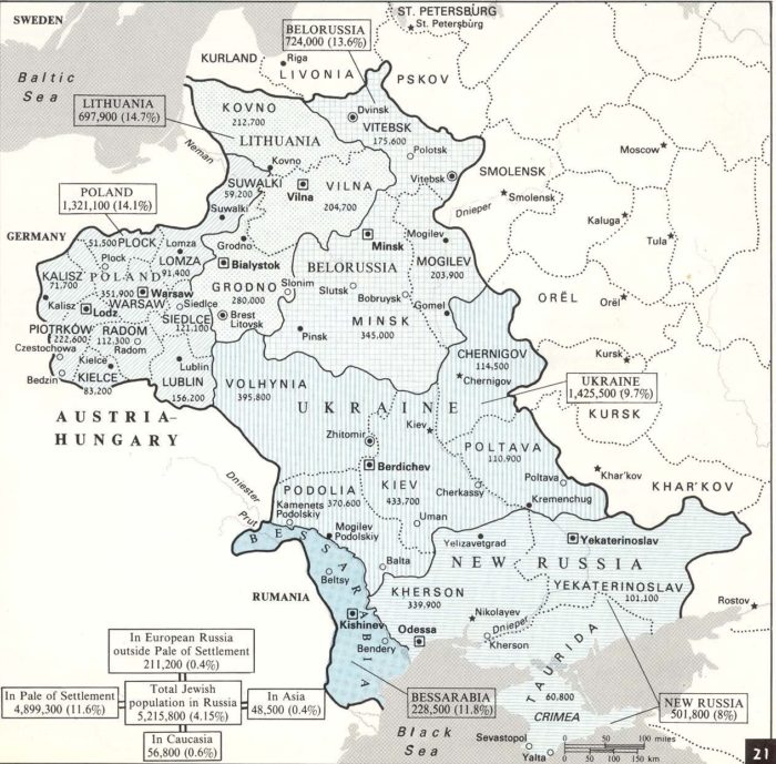
Map source: Atlas of Modern Jewish History by Evyatar Friesel
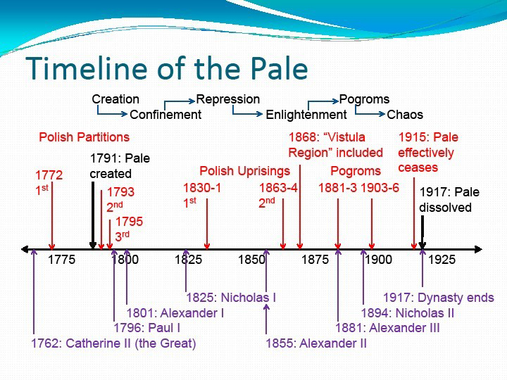
Timeline of the Pale
The history of the Pale can be thought of as going through six stages:
Creation, Confinement, Repression, Enlightenment, Pogroms and Chaos.
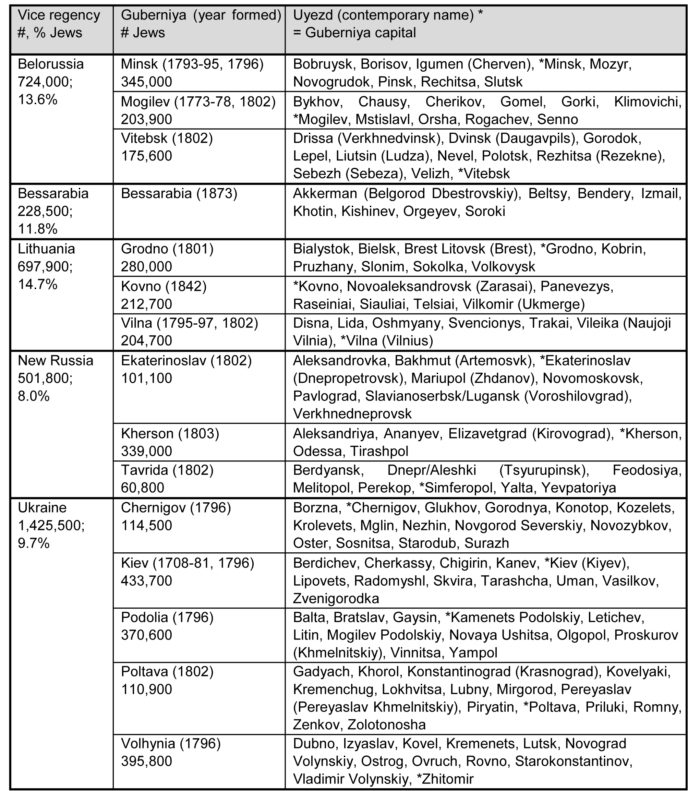
The Pale of Jewish Settlement consisted of the Belorussia, Bessarabia, Lithuania, New Russia, and Ukraine Vice regencies. Each vice regency was composed of guberniya (provinces) which were composed of uyezd (districts). Normally, the name of an uyezd was generally the same as its chief town. When the town had a different name, it is shown as “Uyezd/Town.” The chart below shows these political breakdowns. The population figures are from the 1897 Russian census as shown in the Atlas of Modern Jewish History by Evyatar Friesel. The list of uyezds by guberniya is from the Great Soviet Encyclopedia. The contemporary names (in parenthesis) are from Where Once We Walked by Gary Mokotoff and Sallyann Sack.
In 1815, the Kingdom of Poland was reconstituted at the Congress of Vienna, with the Russian Tsar as King. The resultant entity was referred to as Congress Poland (“Kongresowka”) and was divided into palatinates or voivoidships (“Wajewodztwa” in Polish). These included Cracow, Sandomier, Lublin, Podlachia, Kalisz, Plock, Warsaw, and Augustowo. The first four covered Polish lands that had been occupied by the Austrian Empire as Western Galicia. The latter four covered Polish lands that had been occupied by Prussia.
After two unsuccessful Polish uprisings, Congress Poland ceased to be a separate country and was consolidated into the Russian empire as “Vistulaland”, though it often continued to be referred to as Congress Poland or the Kingdom of Poland. Concurrently, the provinces were redrawn into ten guberniya, and administered in the Russian fashion. Kielce was created out of Cracow Voivoidship. Radom was fashioned out of Sandomier. Podlachia was renamed Siedlce. Augustowo was divided into two guberniya, Suwalki in the north and Lomza in the south. Piotrkow was formed from portions of four voivoidships, Cracow, Sandomier, Kalisz, and Warsaw. The other voivoidships retained their names as they were converted to guberniya.
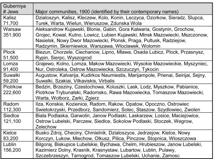
In the census of 1897, Congress Poland contained 1,321,100 Jews, who constituted 14.1% of the population. The chart below lists the ten Congress Poland guberniyas and some significant communities in each at the turn of the century. The communities shown are those on the map of Russia in the 1900 edition of The Century Dictionary and Cyclopedia.